Note
Go to the end to download the full example code.
Version Differences (Altitude)#
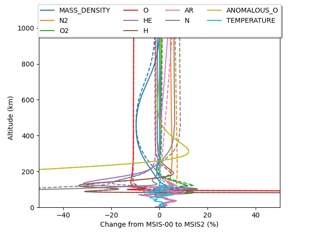
This example demonstrates how to calculate the percent change along an altitude profile between MSIS version 00 and 2. Additionally, we show the difference between densities at noon (solid) and midnight (dashed).

import matplotlib.pyplot as plt
import numpy as np

import pymsis


lon = 0
lat = 70
alts = np.linspace(0, 1000, 1000)
f107 = 150
f107a = 150
ap = 7
aps = [[ap] * 7]

date = np.datetime64("2003-01-01T00:00")
output_midnight2 = pymsis.calculate(date, lon, lat, alts, f107, f107a, aps)
output_midnight0 = pymsis.calculate(date, lon, lat, alts, f107, f107a, aps, version=0)
diff_midnight = (output_midnight2 - output_midnight0) / output_midnight0 * 100

date = np.datetime64("2003-01-01T12:00")
output_noon2 = pymsis.calculate(date, lon, lat, alts, f107, f107a, aps)
output_noon0 = pymsis.calculate(date, lon, lat, alts, f107, f107a, aps, version=0)
diff_noon = (output_noon2 - output_noon0) / output_noon0 * 100


#  output is now of the shape (1, 1, 1, 1000, 11)
# Get rid of the single dimensions
diff_midnight = np.squeeze(diff_midnight)
diff_noon = np.squeeze(diff_noon)

_, ax = plt.subplots()
for variable in pymsis.Variable:
    if variable.name in ("NO", "Total mass density", "Temperature"):
        # There is currently no NO data for earlier versions,
        # also ignore non-number densities
        continue
    (line,) = ax.plot(diff_midnight[:, variable], alts, linestyle="--")
    ax.plot(diff_noon[:, variable], alts, c=line.get_color(), label=variable.name)

ax.legend(
    loc="upper center", bbox_to_anchor=(0.5, 1.15), fancybox=True, shadow=True, ncol=4
)
ax.set_title(f"Longitude: {lon}, Latitude: {lat}")
ax.set_xlim(-50, 50)
ax.set_ylim(0, 1000)
ax.set_xlabel("Change from MSIS-00 to MSIS2 (%)")
ax.set_ylabel("Altitude (km)")

plt.show()
Total running time of the script: (0 minutes 0.102 seconds)
